


Offered by:
Arader Galleries
1016 Madison Avenue
New York City, NY 10075 , United States
Call Seller
215.735.8811
Showrooms
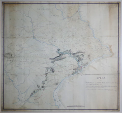
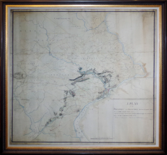
A PLAN OF THE PROGRESS OF THE ROYAL ARMY FROM THEIR LANDING
-
Description
Charles Blaskowitz (c.1743- 1823)
A Plan of the Progress of the Royal Army from their Landing at Elk Ferry to Philadelphia 1777 Under the Command Of His Excellency, Sir William Howe Knight of the most Honorable Order of the Bath, Commander and Chief Surveyed and Drawn by Order of Major General Sir William Erskine by Charles Blaskowitz Capt. of the Corps Guide
Philadelphia, 1778
On laid paper, mounted on linen
51 3/8 x 53 1/8” (sheet size), Framed to full museum specifications
AN EXTRAORDINARY REVOLUTIONARY CAMPAIGN MAP OF THE DELAWARE VALLEY
Blaskowitz’s map presents a precise and detailed description of southeastern Pennsylvania and the adjacent parts of Maryland, Delaware and New Jersey. All roads and villages are illustrated with ink and watercolor. A detailed topographic projection crosses the lower half of the map moving northwards from the head of the Chesapeake Bay to Philadelphia. This marks the route of the British army as it progressed against determined Continental resistance to seize the American capital in September 1777. The site of the two large field battles, Brandywine and Germantown, are illustrated, as is the siege of Fort Mifflin in the Delaware River. Daily progress is tracked, and its locations of country taverns and meetinghouses are labeled, while crossed swords indicate the locations of skirmishes and red bars show the placement of brigades. It is a complete rendering of the dramatic sequence of events as they occurred from August to December 1777.
The areas in the vicinity of the route of the British armies are rendered in full topographical detail, while the remainder of the map takes on the form of a road and administrative map. As indicated on the title, Blaskowitz drafted the map under the orders of Major General Sir William Erskine (1728-1795), one of the most highly regarded commanders in the British Army. At the time it was created, it was likely the most detailed and precise map of southeastern Pennsylvania. The map is a detailed record of the British campaign to take Philadelphia, the capital of the United States, during the late summer and autumn of 1777. -
More Information
Documentation: Documented elsewhere (similar item) Period: 19th Century Condition: Good. Styles / Movements: Traditional Incollect Reference #: 639196
Message from Seller:
Founded in 1971, Arader Galleries is the leading dealer of rare maps, prints, books, and watercolors from the 16th to 19th centuries. Visit us at 1016 Madison Avenue, NYC, or contact us at 215.735.8811 | loricohen@aradergalleries.com |
More Listings from Arader Galleries View all 1351 listings
-
DELAWARE VALLEY DRESSING TABLE (INV. 0331)
-
THE WIDOW OF AN INDIAN CHIEF WATCHING THE ARMS OF HER DECEASED HUSBAND

-
A LOUIS XIV ORMOLU-MOUNTED AND BRASS-INLAID EBONIZED BOOKCASE

-
DELAWARE VALLEY, 1760-90, DROP-LEAF OR DINING TABLE (INV. 0355)

-
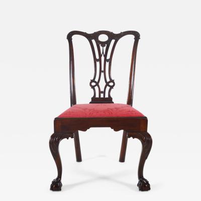
PHILADELPHIA SIDE CHAIR (INV. 0028)
-
VERY FINE AND RARE CHIPPENDALE CARVED AND FIGURED MAHOGANY DESK-AND-BOOKCASE

-
ANGLO-CHINESE SCHOOL, PINEAPPLE

-
PHILADELPHIA WALNUT CHEST ON FRAME

-
NORTHERN DELAWARE OR SOUTHEASTERN PENNSYLVANIA HIGH CHEST OF DRAWERS

-
PHILADELPHIA DRESSING TABLE (INV. 0327)

-
DROP-LEAF OR DINING TABLE, NEWPORT, RHODE ISLAND, 1780-95 (INV. 0348)

-
PHILADELPHIA, 1765-80, SIDE CHAIR (INV. 0357)
-
PENNSYLVANIA WALNUT TALL CHEST ON FRAME (Inv. 320)

-
PHILADELPHIA CARD TABLE (INV. 0301)