


Offered by:
The Great Republic
1 Lake Circle
Colorado Springs, CO 80906 , United States
Call Seller
719.471.6157
Showrooms
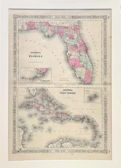
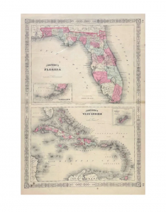
1865 "Johnson's Florida" and "Johnson's West Indies" Map by Johnson and Ward
-
Description
Presented is an original 1865 "Johnson's Florida" map and “Johnson’s West Indies” map. These map was issued as pages 43 and 44 in the 1865 edition of “Johnson's New Illustrated (Steel Plate) Family Atlas.” The maps are engraved, with attractive hand coloring and a decorative strapwork border.
In “Johnson’s Florida,” Florida is all labeled, outlined in pink, and colored by county. Depicted but not colored are the neighboring states of Alabama and Georgia. The map is beautifully detailed, with railroads, roads, rivers and creeks, and important cities and towns all marked. The map shows both the Atlantic Ocean and the Gulf of Mexico. An inset map of “Florida Keys” can be found at the bottom of this map. This map was first issued in 1864.
In “Johnson’s West Indies,” the countries of Cuba, Bahama Islands, Jamaica, St. Domingo, Porto Rico, Caribee Islands, Windward Islands, and the Leeward Islands are hand colored and outlines. Depicted but not colored are the bordering countries of Central America and South America, as well as the state of Florida. The map is beautifully detailed, with important cities and towns all marked. It shows excellent water detail with channels, banks, and smaller seas labeled, as well as the Atlantic Ocean, Gulf of Mexico, and the Caribbean Sea. An inset map of “The Bermuda Islands” is at the top of the map.
This 1865 Johnson and Ward publication of “Johnson's New Illustrated (Steel Plate) Family Atlas” was written by Richard Swainson Fisher, M.D. Fisher was also the author of "Colton's General Atlas of the World," "The Gazetteer of the United States," and a past editor of the Journal of American Geographical and Statistical Society. The publishing company of Johnson and Ward was a successor to Johnson and Browning, themselves a successor to the famous publishing company, J. H. Colton and Company. A combination of both new plates and older, updated ones, all of the maps in this atlas were compiled, drawn, and engraved under the supervision of J. H. Colton and A. J. Johnson. The new plates, copyrighted by A.J. Johnson, were made exclusively for Johnson's New Illustrated Family Atlas. Others are the same as used in "Colton's General Atlas."
This early 1865 issued atlas offered a really unique and timely snapshot of the United States and surrounding countries just after the Civil War. In addition to the maps, the atlas had several pages of American history, recent federal census data, and geographical and statistical notes. The highlight was its “Chronological History of the Civil War in America” with battle records and dates. It also contained updates on the assassination of Abraham Lincoln and subsequent pursuit and death of John Wilkes Booth and included two Civil War-era maps, one of the “Vicinity of Richmond and Peninsular Campaign in Virginia” and the “New Military Map of the United States.”
CONDITION:
Fine condition overall. Hand Colored. Page 43 and 44 from “Johnson's New Illustrated (Steel Plate) Family Atlas.” Strapwork border. Colored by county in Florida, uncolored for bordering states of Georgia and Alabama. Publication line at top right : "Entered according to Act of Congress in the Year 1864 by A.J. Johnson in the Clerks Office of the District Court of the United States for the Southern District of New York. " Toning to paper, more noticeable on margins. Small foxing spots. Coloring to the West Indies islands, to include the Bahama Islands, Cuba, Jamaica, St. Domingo, Porto Rico, Caribbee Islands, Windward Islands, and Leeward Islands. Uncolored in bordering countries of Central America and South America and the state of Florida. Toning to paper, more noticeable on margins. Small foxing spots. Archivally presented with acid-free mats. Sold unframed, as-is.
Mat Dimensions: 27" H x 19 5/8" W.
Accompanied by our company's letter of authenticity. -
More Information
Documentation: Certificate of Authenticity Period: 19th Century Condition: Good. Styles / Movements: Traditional Incollect Reference #: 750083 -
Dimensions
W. 19.625 in; H. 27 in; W. 49.85 cm; H. 68.58 cm;
Message from Seller:
Established in 2010, The Great Republic specializes in one-of-a-kind collectibles that honor American history, with a special focus on the rare and unique. Our collection is complete with rarities that are sure to wow, such as first edition books, antique hand-sewn flags from the Civil War, vintage travel posters, and original signatures from American presidents, such as George Washington and Abraham Lincoln, just to name a few. P: 719.471.6157 E: headquarters@great-republic.com
More Listings from The Great Republic View all 255 listings
-
"Fight Or Buy Bonds. Third Liberty Loan" Vintage WWI Poster by Howard Chandler

-
"Famous Brands of the Lone Star State" Santa Fe Railway Texas Travel Poster

-
"Join the Air Service and Serve in France" Vintage WWI Poster

-
"Back 'Em Up. Buy Extra Bonds" Vintage WWII Poster by Boris Chaliapin, 1944

-
O'er the Ramparts We Watch. United States Army Air Forces

-
The Scarlet Letter: A Romance, by Nathaniel Hawthorne

-
"Remember Dec. 7th" Vintage WWII Poster by Allen Saalburg, 1942

-
TGR Handcrafted Humidor, George Washington's 1789 Inaugural Seal or Elephant

-
Life of Andrew Jackson by James Parton, Three Volumes, Later Printing, 1876

-
"General Washington" by Thomas Cheesman, after John Trumbull, 1796

-
"The Death of General Wolfe" Engraving by William Woollett, after Benjamin West

-
13-Star Anchor Nautical Ensign
-
John F. Kennedy Senator Signature Collage
-
"Keep Him Free" Vintage WWI War Savings Stamps Poster by Charles Livingston Bull

